Puntledge River Reports
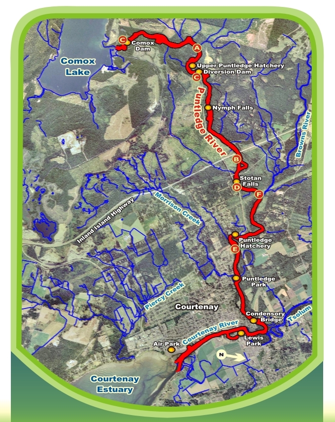


Click on the flashing newts to discouver the project names and project dates at each location.
Reports
2014
Assesment of the homing behaviour of 3 and 4 year old Puntledge Summer Chinook adult returns from lake and river released juveniles
2013
Evaluation of Natural and Hatchery Summer Chinook and Coho Production in the Upper Puntledge Watershed
2012
Puntledge River Hatchery – Summer Chinook Rearing Consolidation Project
Assessment of Homing Behaviour of Puntledge Summer Chinook Hatchery Returns – Preparations for Adult Assessment Phase
Assessment of Coho and Chinook Smolt/Fry Migration at the Puntledge Diversion Dam Eicher Screens
2011
Puntledge River Hatchery – Summer Chinook Rearing Consolidation Project
Puntledge River Hatchery – Summer Chinook Rearing Consolidation Project
2010
Chinook and Coho Smolt Migration Study
Chinook Spawning Study
Summer Chinook Imprinting Assessment
Lower Puntledge Hatchery Chiller Design
Esther Guimond working on the Chinook & Coho Smolt Migration Study
Big Qualicum Hatchery Holding of Puntledge River Summer Chinook
Population Diversity in Puntledge River Coho
2008
Puntledge Summer Chinook DNA Analysis
Puntledge River Jack Hames Side Channel Intake Replacement
Puntledge River Radio Telemetry Study on Summer Chinook Migration in the Upper Watershed
2007
Summer Run Chinook Radio and Electromyography Telemetry Study
Radio Telemetry Study on Summer Chinook Migration in the Upper Watershed
Impoundment and Diversion Dam Fishway Assessment
Headpond Gravel Placement Post-Construction Monitoring
Stotan Falls – Improvement for Adult Summer Chinook Migration
Related Posts
Mallard Creek Restoration Update for 2024
Restoration work in Mallard Creek will continue this year, including invasive removal, restoring connectivity, and trial planting of a new riparian species. Volunteer events starting in September 2024.
Volunteer at Kus-kus-sum Chamber of Commerce Event
We are showing Kus-kus-sum off to businesses in the Valley through a Chamber Business to Business event. We are looking for a few volunteers to assist with this event.
Coastal Plant Monitoring
Get involved with our new vegetation community science monitoring program!
Spring Field Trips
Throughout May and June Project Watershed will be taking elementary school classes out on field trips to learn about estuary and coastal ecology and to assist with planting and plant maintenance.
Working Together to Identify Forage Fish Spawning Beaches
This year marks the 5th year of a partnership between Comox Valley Project Watershed Society and North Island College on a long-term study to examine intertidal spawning habitats of forage fish in the northern Salish Sea.
Glen Urquhart Update – Spring 2024
Latest news from Glen Urquhart restoration progress for spring 2024.