Your contribution is greatly appreciated, thank you for participating!
Welcome to our pinniped observation guide and data submission page! “Pinniped” is a Latin word meaning “fin-footed,” and includes marine mammals with front and hind flippers such as seals and sea lions. Thank you for your time to help us observe pinniped activity in the Courtenay River. Please review all information prior to completing the data form. If you have any questions or need additional information please email Jay Baker-French.
Background
Harbour seals and sea lions (pinnipeds) are known to hunt salmon in the Courtenay River near Kus-kus-sum. Seal hunting activity is common and well documented in that area, but sea lions are far less common, and their activity near Kus-kus-sum is not well understood. Anecdotal evidence suggests that seals use the steel walls at Kus-kus-sum to herd and catch salmon, thereby increasing fish predation in this important salmon migration corridor. By comparing pinniped presence and behavior at Kus-kus-sum before and after the wall is removed to nearby intact marsh habitat, the impact of the wall on their hunting success can be better understood. This will especially be important to demonstrate how restoration of Kus-kus-sum will reduce the predatory impacts of pinnipeds on salmon populations.
Before You Head Out
Project Watershed will schedule training sessions throughout the year. Training is not required to make observations, however we encourage volunteers to attend at least one session so you have a chance to ask questions and see the full protocol in person.
Supplies
- Paper data sheet (link to datasheet) or mobile device if you’re recording your data electronically
- Pencils (pens ok, but pencil recommended)
- Time piece: watch, phone, etc. You need to record the exact start and stop times at each observation site
- Binoculars (not required, but highly recommended)
- A camera to photograph your datasheet (your phone is easiest; you can do this after you finish the observation exercise).
- Reflective vest (not required, but highly recommended)
Safety
Please be aware of your surroundings and take care to not endanger yourself while making observations. We strongly recommend the ‘buddy system’ – not only will this make the observations more efficient and fun, but it is the best way to prevent accidents and ensure you have assistance in the case of an emergency.
- Never approach wildlife. If you observe an injured animal or suspect animal abuse, please call MARS Wildlife Rescue at (250) 337-2021 or (250) 897-2257 (after-hours).
- Follow all pedestrian and traffic laws, such as using designated crosswalks and parking in designated areas.
- Please stay on designated paths and walkways to avoid the risk of slips and falls into the river.
- Be mindful of and courteous to bicycles, joggers and pedestrians along paths and sidewalks.
- Be visible and predictable, especially on shared bike paths and bridges. Reflective, high-vis clothing is recommended for working on the bridge.
- Bring water, snacks, hats/sunscreen, or extra layers to keep yourself comfortable during your monitoring session.
- If you are making observations alone, please let someone know where you are, and what time you expect to return.
Instructions
General Instructions/Notes
There are 7 sites where pinnipeds are observed along the Courtenay River. Observations are made for exactly 10 minutes at each site (even if there are no pinnipeds at the site).
When you arrive at each site:
-
- Orient yourself. Identify landmarks where your observations will start and stop.
- Make sure to monitor both upstream and downstream.
- Record the number of animals and their activities using one of the three methods detailed below (different behaviour types are described in the “Behaviours” section below).
- Before you move on to the next site, ensure that all data fields are complete. Collecting Data Using the Website Map
Choose a Data Collection Method:
There are three methods for data collection. Please choose a single method and read through the instructions before heading out.
- Collect Data Directly on the Website Map (Requires Internet)
-
- This is the easiest method to use if you anticipate having internet access in the field.
- This method involves opening the web map on your mobile device and entering data for each site you monitor.
- Download detailed instructions here.
- Link to website map (where you can input your data).
-
- Collect Data Using the Field Maps App (Does not Require Internet)
-
- Quickest method to use once set up. Does not require internet access in the field.
- This method involves downloading the ArcGIS Field Maps app on your mobile device and signing in to our account (login details provided after you complete a training session).
- Download detailed instructions here.
-
- Collect Data Using a Physical Datasheet
-
- Use this method if apps and online maps are confusing for you.
- This method involves printing out a paper copy of the datasheet, filling it out in the field, and then using Method 1 (described above) to submit your data when you get home.
- Download detailed instructions here.
- Download datasheet here.
-
Behaviours
Pinniped hunting behaviours & techniques include:
-
- Fast movements through the water
- Abrupt changes of direction
- Upside-down behaviour (swimming while scanning under the water surface)
- Splashing / flipping out of the water
- Quick, consistent surfacing events
- Forming lines across the Courtenay River
- Herding fish against the river bank or steel walls at Kus-kus-sum
- Generating a wake by moving quickly through the water
- Partially leaving the water to capture a fish near the surface
- “Successful” catches are observations of a pinniped with a fish in its mouth, or actively eating a fish
Non-hunting behaviours include:
-
- Swimming slowly or floating, generally just the head is visible (milling)
- Resting on the riverbank
- Playing with other pinnipeds (two or more pinnipeds are moving, but don’t exhibit hunting techniques or you don’t see them catching/eating fish)
FAQ
Why are you monitoring the seals and sea lions?
Seals and sea lions (pinnipeds) are predators at the top of the food chain, so they can have an impact on salmon populations. We want to understand how pinniped hunting in the Courtenay River might be affecting salmon populations throughout the year, especially while we’re completing a large restoration project.
What is the difference between a seal and a sea lion?
A sea lion is bigger, has longer fins and is noiser than a seal. Sea lions have ear flaps and seals have ear holes. Seals move their back flippers side to side like a fish tail when swimming, while sea lions propel themselves with their long front flippers, moving them like oars. Thanks to Veronique McIntyre we have a photo of each below to help you discern the difference when you are out in the field!
-
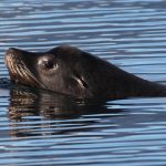
- Sea Lion
-
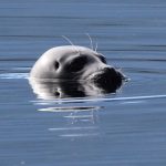
- Seal
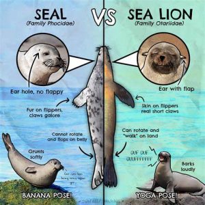
And here’s a helpful graphic from Just Keep Thinking illustrating the key differences:
Do I have to survey all 8 sites and/or do they have to be on the same day?
No, but: we strongly prefer all 8 sites to be surveyed, and we strongly prefer that they are all surveyed on the same day. This will ensure we have the most complete and accurate data. Please make every effort to survey all 8 sites, and visit all 8 on the same day.
However, we understand folks have different constraints and time limitations. We’ll be glad to use any observations you make! If you have to cut your observations short, please be sure to observe at sites 5, 6, and 7. Please get in touch if you have concerns.
Do I have to survey the sites in site order (1-8)?
No. But: please record the environmental data for each site during the timeframe you were there!
How long does it take to survey all 8 sites?
Each site must be observed for 10 minutes, plus the time to get between sites and ensure your datasheet is complete at each site. We suggest allowing 2.5 hours to complete the entire monitoring protocol (more time for beginners or folks who like to take their time).
Where do I get the observation data sheet?
Please download a copy from [link]. If you cannot download or print, please contact Virginia East at Virginia.East@projectwatershed.ca
Should I use the paper data sheet or the webform when making observations?
You should use whichever method is most comfortable for you while you’re “in the field.” We strongly recommend using the paper data sheet until you are familiar with the webform submission. The biggest need is to submit the data to the webform within 48 hours of your observations so we can ensure your hard work is counted!
Do you need the paper data sheet after I’m done?
When you submit your data through the webform, you should be prompted to upload photos of your datasheet. Once you have confirmation that your data were submitted, please recycle your paper data sheet.
If you cannot send your photo or data through the webform, please photograph the data sheet and email it to Stefanie.Lane@projectwatershed.ca
What will happen to the data? Will my name or information be made public?
We will use the data to assess changes in pinniped presence, abundance, and hunting success during the Kus-kus-sum restoration project. We will share the data with K’ómoks First Nation to help support their cultural practices and objectives.
Each observation record that you submit receives a random number ID. All personally identifying information (PII) like your name or email address is used only for Project Watershed volunteer communication purposes, and is not shared with the pinniped observation data.
